File:Bass Strait islands.png
From SpottingWorld, the Hub for the SpottingWorld network...

Size of this preview: 631 × 480 pixels. Other resolutions: 316 × 240 pixels | 693 × 527 pixels.
Original file (693 × 527 pixels, file size: 273 KB, MIME type: image/png)
|

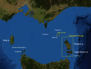
| Description |
Map of Bass Strait including major islands and island groups. |
|---|---|
| Source |
Background imagery derived from NASA World Wind. |
| Date |
2006-04-15 |
| Author | |
| Permission (Reusing this file) |
See below. |
File history
Click on a date/time to view the file as it appeared at that time.
| Date/Time | Thumbnail | Dimensions | User | Comment | |
|---|---|---|---|---|---|
| current | 18:22, 6 July 2010 | | 693 × 527 (273 KB) | Admin (talk | contribs) | {{GFDL-user|Chuq |en|migration=relicense}} {{Information |Description= Map of Bass Strait including major islands and island groups. |Source=Background imagery derived from NASA World Wind. |Date=2006-04-15 |Author= en:Benutzer:Chuq |other_versions=none }} Category:Islands of Tasmania Category:Maps of islands of Australia Category:Satellite pictures of Australia Category:Bass Strait |
- You cannot overwrite this file.
File usage
The following page links to this file:
