File:Kyrill MSC Napoli.png
From SpottingWorld, the Hub for the SpottingWorld network...

Size of this preview: 600 × 480 pixels. Other resolutions: 300 × 240 pixels | 1,000 × 800 pixels.
Original file (1,000 × 800 pixels, file size: 45 KB, MIME type: image/png)
| Description |
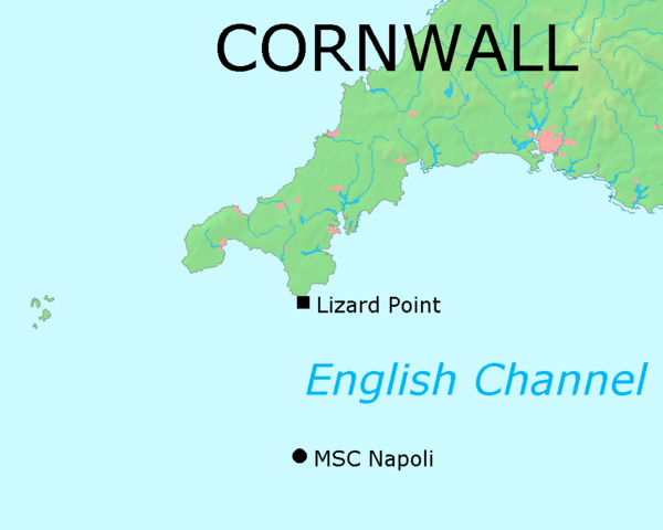
Die Karte beruht auf de::Bild:Map of Cornwall.png auf Commons. Die Position des in Seenot geratenen Containerschiffs MSC Napoli wurde durch Anwendung von Strahlensätzen anhand einer Karte der BBC (_42465905_lizard_pt_map203.gif) bestimmt. |
|---|---|
| Source |
Originally from de.wikipedia; description page is/was here. |
| Date |
2007-01-19 (original upload date) |
| Author |
Original uploader was Matthiasb at de.wikipedia |
| Permission (Reusing this file) |
This image is in the public domain. |
License information
Original upload log
(All user names refer to de.wikipedia)
- 2007-01-19 10:51 Matthiasb 1000×800×8 (46460 bytes) Die Karte beruht auf [[Bild:Map of Cornwall.png]] auf Commons. Die Position des in Seenot geratenen Containerschiffs MSC Napoli wurde durch Anwendung von Strahlensätzen anhand einer Karte der BBC (_42465905_lizard_pt_map203.gif) bestimmt.
File history
Click on a date/time to view the file as it appeared at that time.
| Date/Time | Thumbnail | Dimensions | User | Comment | |
|---|---|---|---|---|---|
| current | 09:34, 11 July 2010 | | 1,000 × 800 (45 KB) | Admin (talk | contribs) | {{Information |Description=Die Karte beruht auf de::Bild:Map of Cornwall.png auf Commons. Die Position des in Seenot geratenen Containerschiffs MSC Napoli wurde durch Anwendung von Strahlensätzen anhand einer Karte der BBC (_42465905_lizard_pt_map203.gif) bestimmt. |Source=Originally from [http://de.wikipedia.org de.wikipedia]; description page is/was [http://de.wikipedia.org/w/index.php?title=Image%3AKyrill_MSC_Napoli.png here]. |Date=2007-01-19 (original upload date) |Author=Original uploader was Matthiasb at [http://de.wikipedia.org de.wikipedia] |Permission=This image is in the public domain. |other_versions= }} == License information == {{PD-ineligible}} <!-- Templates "Template:Lizenzdesign2" were used in the original description page as well , but do not appear to exist on commons. --> == Original upload log == (All user names refer to de.wikipedia) * 2007-01-19 10:51 Matthiasb 1000×800×8 (46460 bytes) ''<nowiki>Die Karte beruht auf Bild:Map of Cornwall.png auf Commons. Die Position des in Seenot geratenen Containerschiffs MSC Napoli wurde durch Anwendung von Strahlensätzen anhand einer Karte der BBC (_42465905_lizard_pt_map203.gif) bestimmt.</nowiki>'' __NOTOC__ Category:MSC Napoli Category:Cornwall |
- You cannot overwrite this file.
File usage
The following page links to this file:
