File:Nederlandsindie.PNG

| Description |
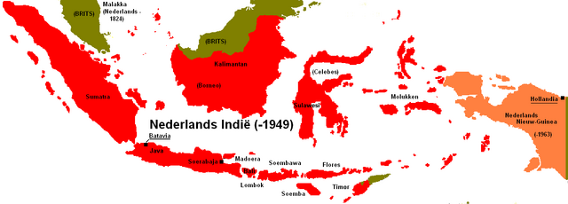
English: Map of the Dutch East Indies showing the full extent of its boundaries in the early 20th century. Template:Eo (Finnish) Template:Fy Template:Hr Template:Ja Template:Jv |
|---|---|
| Source |
Originally from nl.wikipedia; description page is/was here. |
| Date |
2006-11-11 (original upload date) |
| Author |
Original uploader was Clockwork Orange at nl.wikipedia |
| Permission (Reusing this file) |
SELF2 |
Licensing:
 Permission is granted to copy, distribute and/or modify this document under the terms of the GNU Free Documentation License, Version 1.2 or any later version published by the Free Software Foundation; with no Invariant Sections, no Front-Cover Texts, and no Back-Cover Texts.
|
Original upload log
(All user names refer to nl.wikipedia)
- 2006-11-11 21:36 Clockwork Orange 1254×450×8 (36330 bytes)
File history
Click on a date/time to view the file as it appeared at that time.
| Date/Time | Thumbnail | Dimensions | User | Comment | |
|---|---|---|---|---|---|
| current | 14:24, 26 June 2010 | 1,254 × 450 (35 KB) | Admin (talk | contribs) | {{Information |Description={{cs|Nizozemská východní Indie.}} {{de|Niederländisch-Indien. Indonesien bei Erreichen der Unabhängigkeit 1949 (rot).}} {{en|Map of the Dutch East Indies showing the full extent of its boundaries in the early 20th century.}} {{eo|Nederlanda Hindio.}} {{fi|Alankomaiden Itä-Intian rajat 1900-luvun alussa.}} {{fy|Nederlânsk-Ynje.}} {{hr|Područje Nizozemske istočne Indije.}} {{ja|オランダ領東インドの領域.}} {{jv|Péta jajahan Hindhia-Walanda.}}<!--Description fetched by DieBucheBot--> |Source=Originally from [http://nl.wikipedia.org nl.wikipedia]; description page is/was [http://nl.wikipedia.org/w/index.php?title=Image%3ANederlandsindie.PNG here]. |Date=2006-11-11 (original upload date) |Author=Original uploader was Clockwork Orange at [http://nl.wikipedia.org nl.wikipedia] |Permission=SELF2|GFDL|CC-BY-SA-2.5. |other_versions= }} == {{int:license}} == {{Self|GFDL|Cc-by-sa-3.0-migrated|cc-by-sa-2.5}} == Original upload log == (All user names refer to nl.wikipedia) * 2006-11-11 21:36 Clockwork Orange 1254×450×8 (36330 bytes) ''<nowiki></nowiki>'' Category:Dutch East Indies |
- You cannot overwrite this file.
File usage
The following 2 pages link to this file:
