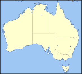
File:Australia Locator Blank.svg
From SpottingWorld, the Hub for the SpottingWorld network...

Size of this PNG preview of this SVG file: 290 × 262 pixels. Other resolution: 266 × 240 pixels.
Original file (SVG file, nominally 290 × 262 pixels, file size: 126 KB)
| Description |
This map image was created by Wikipedia user Papayoung, based on the public-domain data available through the Map-It interface. Please note: This image is intended for use as a base map for a locator image; if you change or replace it in a way that moves its geographic features, images superimposed on it at specific locations will no longer be accurate. Please be careful. Thank you.
Grid to use to find position for a locator map: en::Image:Australia grid.png, en::Image:Australia grid2.png |
|---|---|
| Source |
Originally from en.wikipedia; description page is/was here. |
| Date |
2005-10-31 (first version); 2007-03-13 (last version) |
| Author |
Original uploader was Papayoung at en.wikipedia Later versions were uploaded by Wereon at en.wikipedia. |
| Permission (Reusing this file) |
Released under the GNU Free Documentation License. |
License information
 |
Permission is granted to copy, distribute and/or modify this document under the terms of the GNU Free Documentation License, Version 1.2 or any later version published by the Free Software Foundation; with no Invariant Sections, no Front-Cover Texts, and no Back-Cover Texts. Subject to disclaimers. |
Original upload log
(All user names refer to en.wikipedia)
- 2007-03-13 01:34 Wereon 290×262×0 (128952 bytes) rm artefacts
- 2005-10-31 03:30 Papayoung 290×262×0 (102267 bytes) This map image was created by Wipedia user [[wp:User:Papayoung|Papayoung]], based on the public-domain data available through the [http://stellwagen.er.usgs.gov/mapit/ Map-It] interface.
File history
Click on a date/time to view the file as it appeared at that time.
| Date/Time | Thumbnail | Dimensions | User | Comment | |
|---|---|---|---|---|---|
| current | 14:10, 26 June 2010 |  | 290 × 262 (126 KB) | Admin (talk | contribs) | {{Information |Description=This map image was created by Wikipedia user Papayoung, based on the public-domain data available through the [http://stellwagen.er.usgs.gov/mapit/ Map-It] interface. <div style="border: 1px solid #F66; padding: 1em;">'''Please note:''' This image is intended for use as a base map for a locator image; if you change or replace it in a way that moves its geographic features, images superimposed on it at specific locations will no longer be accurate. ''Please be careful.'' Thank you.</div> Grid to use to find position for a locator map: en::Image:Australia grid.png, en::Image:Australia grid2.png |Source=Originally from [http://en.wikipedia.org en.wikipedia]; description page is/was [http://en.wikipedia.org/w/index.php?title=Image%3AAustralia_Locator_Blank.svg here]. |Date=2005-10-31 (first version); 2007-03-13 (last version) |Author=Original uploader was Papayoung at [http://en.wikipedia.org en.wikipedia] Later versions were uploaded by Wereon at [http://en.wikipedia.org en.wikipedia]. |Permission=Released under the GNU Free Documentation License. |other_versions= }} == License information == {{GFDL-en|migration=relicense}} == Original upload log == (All user names refer to en.wikipedia) * 2007-03-13 01:34 Wereon 290×262×0 (128952 bytes) ''<nowiki>rm artefacts</nowiki>'' * 2005-10-31 03:30 Papayoung 290×262×0 (102267 bytes) ''<nowiki>This map image was created by Wipedia user Papayoung, based on the public-domain data available through the [http://stellwagen.er.usgs.gov/mapit/ Map-It] interface.</nowiki>'' __NOTOC__ Category:Locator maps of Australia Category:Location maps |
- You cannot overwrite this file.
File usage
The following 2 pages link to this file:
