File:Bass Strait infrastructure.png
From SpottingWorld, the Hub for the SpottingWorld network...
No higher resolution available.
Bass_Strait_infrastructure.png (500 × 467 pixels, file size: 191 KB, MIME type: image/png)
| Description |
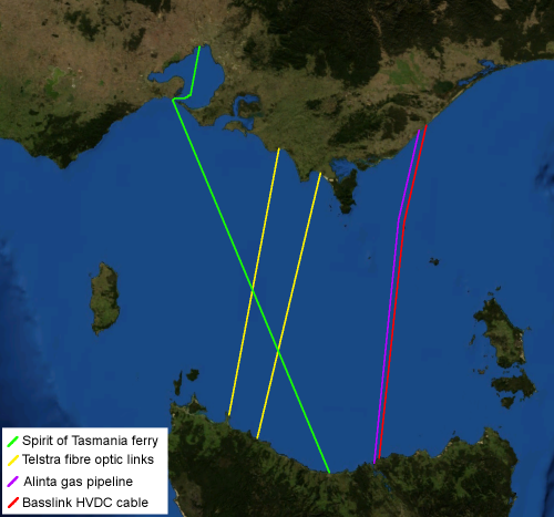
English: Map of Bass Strait including electrical, gas, communications and transport infrastructure. Background imagery derived from NASA World Wind. Template:He |
|---|---|
| Source |
Transferred from en.wikipedia; transferred to Commons by wp:User:Yuval Y using CommonsHelper. |
| Date |
2006 (original upload date) |
| Author |
Original uploader was Chuq at en.wikipedia |
| Permission (Reusing this file) |
NORIGHTSRESERVED; PD-AUTHOR; Released into the public domain (by the author). |
Licensing:
Template:PD-Nasa Template:PD-user-en
Original upload log
The original description page is/was here. All following user names refer to en.wikipedia.
- 2006-04-15 06:46 Chuq 500×467× (195974 bytes) Map of [[Bass Strait]] including electrical, gas, communications and transport infrastructure. Background imagery derived from [[NASA World Wind]].
File history
Click on a date/time to view the file as it appeared at that time.
| Date/Time | Thumbnail | Dimensions | User | Comment | |
|---|---|---|---|---|---|
| current | 18:22, 6 July 2010 | | 500 × 467 (191 KB) | Admin (talk | contribs) | {{Information |Description={{en|Map of Bass Strait including electrical, gas, communications and transport infrastructure. Background imagery derived from NASA World Wind.}} {{he|חיבורי תשתית עיקריים בין טסמניה ומדינת ויקטוריה}} |Source=Transferred from [http://en.wikipedia.org en.wikipedia]; transferred to Commons by wp:User:Yuval Y using [http://tools.wikimedia.de/~magnus/commonshelper.php CommonsHelper]. |Date={{Date|2006|04|15}} (original upload date) |Author=Original uploader was Chuq at [http://en.wikipedia.org en.wikipedia] |Permission=NORIGHTSRESERVED; PD-AUTHOR; Released into the public domain (by the author). |other_versions= }} == {{int:license}} == {{PD-Nasa}} {{PD-user-en|Chuq}} <!-- Templates "Template:File other" were used in the original description page as well , but do not appear to exist on commons. --> == Original upload log == The original description page is/was [http://en.wikipedia.org/w/index.php?title=Image%3ABass_Strait_infrastructure.png here]. All following user names refer to en.wikipedia. * 2006-04-15 06:46 Chuq 500×467× (195974 bytes) ''<nowiki>Map of Bass Strait including electrical, gas, communications and transport infrastructure. Background imagery derived from NASA World Wind.</nowiki>'' __NOTOC__ Category:Bass Strait Category:Victoria, Australia Category:Victoria, Australia# Category:Infrastructure in Australia |
- You cannot overwrite this file.
File usage
The following page links to this file:
