File:Mississippi-Coast-towns-NOAA.jpg

Summary
| Description |
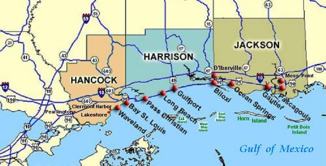
Coastal map of the U.S. state of Mississippi, showing major towns and cities in the 3 coastal counties: Hancock, Harrison, and Jackson County. Also shown are Cat Island, West Ship Island, East Ship Island, Horn Island and Petit Bois Island.The locations of towns, roads and offshore islands are based on NOAA and NASA maps. |
|---|---|
| Source |
self-made (hand-edited with MS-Paint)
The map is in quick JPEG format, for large display as highly readable, in about 20 articles that display the map. JPEG clarity is enhanced by painted areas behind many labels, causing the wording to be clearer than even a massive SVG or PNG-format file could provide, due to the sharp display contrast of JPEG files. JPEG Clarity: Even though JPEG images have artifacts, they can display clearer wording in small maps due to auto-contrast enhancement. The same painted/shaded areas, that illuminate wording, would make the map excessively gargantuan in slow cumbersome PNG or SVG format, as is the case with terrain maps, which also should NEVER be converted to massive PNG format. |
| Date |
2007-06-21 |
| Author | |
| Permission (Reusing this file) |
See below. |
Licensing:
I, the creator of this work, hereby release it into the public domain. This applies worldwide.
In case this is not legally possible,
I grant any entity the right to use this work for any purpose, without any conditions, unless such conditions are required by law.
File history
Click on a date/time to view the file as it appeared at that time.
| Date/Time | Thumbnail | Dimensions | User | Comment | |
|---|---|---|---|---|---|
| current | 08:33, 7 July 2010 | | 750 × 382 (57 KB) | Admin (talk | contribs) | == {{int:filedesc}} == {{Information |Description=Coastal map of the U.S. state of Mississippi, showing major towns and cities in the 3 coastal counties: Hancock, Harrison, and Jackson County. Also shown are Cat Island, West Ship Island, East Ship Island, Horn Island and Petit Bois Island.The locations of towns, roads and offshore islands are based on NOAA and NASA maps. |Source=self-made (hand-edited with MS-Paint) : Reference maps: :* NOAA map of Mississippi counties: [http://www.nws.noaa.gov/om/coop/Coop-map/coop-ms.gif NOAA-Coop-MS]. :* NASA map of towns/roads/islands: [http://www.ssc.nasa.gov/maps/ssc-regional.gif NASA-SSC-regional-map]. The map is in quick JPEG format, for large display as highly readable, in about 20 articles that display the map. JPEG clarity is enhanced by painted areas behind many labels, causing the wording to be clearer than even a massive SVG or PNG-format file could provide, due to the sharp display contrast of JPEG files. JPEG Clarity: Even though JPEG images have artifacts, they can display clearer wording in small maps due to auto-contrast enhancement. The same painted/shaded areas, that illuminate wording, would make the map excessively gargantuan in slow cumbersome PNG or SVG format, as is the case with terrain maps, which also should NEVER be converted to massive PNG format. |Permission= |Date=2007-06-21 |Author= Wikid77 }} {{badJPEG}} == {{int:license}} == {{PD-self|author=I, Wikid77}} Category:Maps of Mississippi Category:Ship Island (Mississippi) |
- You cannot overwrite this file.
File usage
The following page links to this file:
