File:Ship Island after Hurricane Katrina.jpg
Summary
| Description |
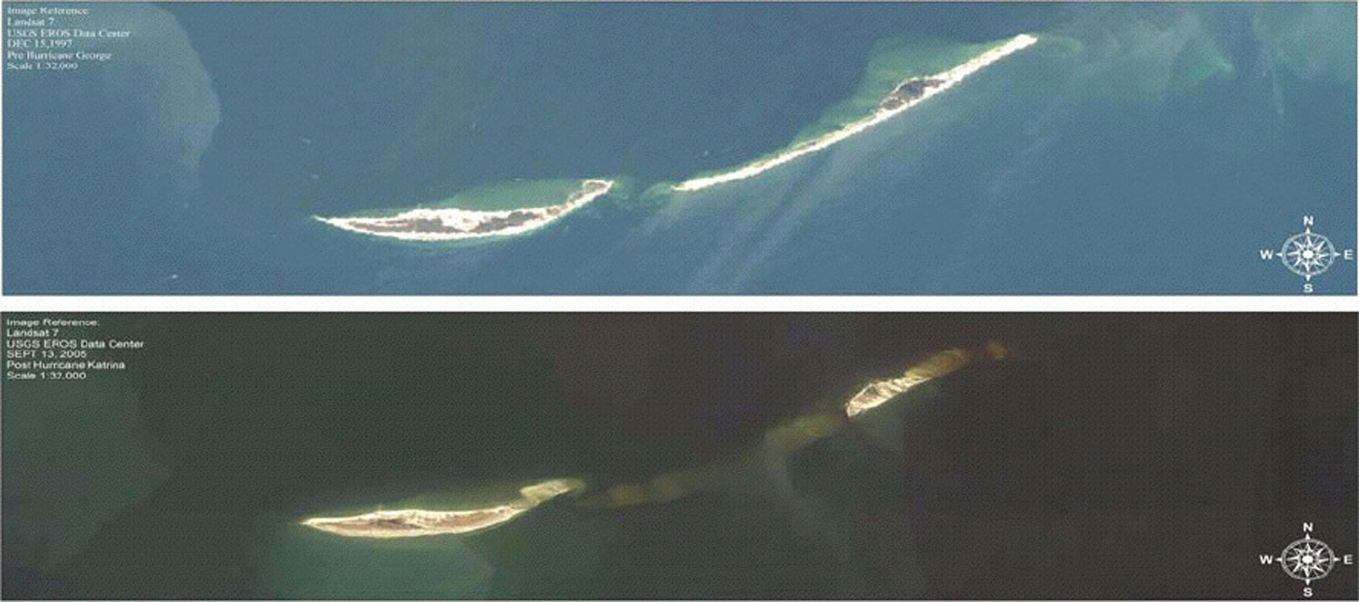
English: Image showing Ship Island in the United States Gulf Coast before Hurricane Katrina and after Hurricane Katrina |
|---|---|
| Source | |
| Date |
2009-03 |
| Author |
United States Geological Survey |
| Permission (Reusing this file) |
See below. |
Template:ImageNote In 1969, Hurricane Camille with its 30-foot (9.1 m) tidal surge cut the island into 2 separate islands, to form East Ship Island and West Ship Island. East Ship Island is mostly vegetation and wildlife while West Ship Island is a tourist destination. Template:ImageNoteEnd Template:ImageNote West Ship Island Template:ImageNoteEnd Template:ImageNote East Ship Island Template:ImageNoteEnd Template:ImageNote Before Hurricane Katrina Template:ImageNoteEnd Template:ImageNote After Hurricane Katrina Template:ImageNoteEnd
Licensing:
File history
Click on a date/time to view the file as it appeared at that time.
| Date/Time | Thumbnail | Dimensions | User | Comment | |
|---|---|---|---|---|---|
| current | 08:50, 7 July 2010 | | 1,500 × 665 (143 KB) | Admin (talk | contribs) | == {{int:filedesc}} == {{Information |Description={{en|1=Image showing Ship Island in the United States Gulf Coast before Hurricane Katrina and after Hurricane Katrina}} |Source=http://soundwaves.usgs.gov/2009/03/ |Author=United States Geological Survey |Date=2009-03 |Permission= |other_versions= }} {{ImageNote|id=1|x=336|y=49|w=953|h=232|dimx=1500|dimy=665|style=2}} In 1969, Hurricane Camille with its 30-foot (9.1 m) tidal surge cut the island into 2 separate islands, to form East Ship Island and West Ship Island. East Ship Island is mostly vegetation and wildlife while West Ship Island is a tourist destination. {{ImageNoteEnd|id=1}} {{ImageNote|id=2|x=326|y=543|w=341|h=60|dimx=1500|dimy=665|style=2}} West Ship Island {{ImageNoteEnd|id=2}} {{ImageNote|id=3|x=908|y=382|w=231|h=88|dimx=1500|dimy=665|style=2}} East Ship Island {{ImageNoteEnd|id=3}} {{ImageNote|id=4|x=41|y=129|w=253|h=101|dimx=1500|dimy=665|style=2}} Before Hurricane Katrina {{ImageNoteEnd|id=4}} {{ImageNote|id=5|x=34|y=455|w=238|h=97|dimx=1500|dimy=665|style=2}} After Hurricane Katrina {{ImageNoteEnd|id=5}} == {{int:license}} == {{PD-USGov-USGS}} Category:Ship Island (Mississippi) |
- You cannot overwrite this file.
File usage
The following page links to this file:
