File:Woolwich Ferry map.svg
From SpottingWorld, the Hub for the SpottingWorld network...

Size of this PNG preview of this SVG file: 640 × 466 pixels. Other resolution: 320 × 233 pixels.
Original file (SVG file, nominally 931 × 678 pixels, file size: 18 KB)
Summary
| Description |
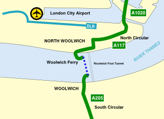
A simple map showing the Woolwich Ferry crossing of the River Thames with the nearby Docklands Light Railway and London City Airport |
|---|---|
| Source |
Own work |
| Date |
2007-11-12 |
| Author | |
| Permission (Reusing this file) |
See below. |
Licensing:
 Permission is granted to copy, distribute and/or modify this document under the terms of the GNU Free Documentation License, Version 1.2 or any later version published by the Free Software Foundation; with no Invariant Sections, no Front-Cover Texts, and no Back-Cover Texts.
|
File history
Click on a date/time to view the file as it appeared at that time.
| Date/Time | Thumbnail | Dimensions | User | Comment | |
|---|---|---|---|---|---|
| current | 09:02, 7 July 2010 | | 931 × 678 (18 KB) | Admin (talk | contribs) | == {{int:filedesc}} == {{Information |Description=A simple map showing the Woolwich Ferry crossing of the River Thames with the nearby Docklands Light Railway and London City Airport |Source={{own}} |Date=2007-11-12 |Author= Cnbrb |Permission= |other_versions= }} == {{int:license}} == {{self|GFDL|cc-by-3.0}} Category:London River Services Category:Public transport maps of London |
- You cannot overwrite this file.
File usage
The following page links to this file:
