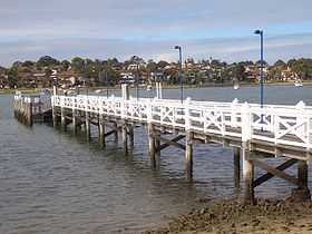
Bayview Park ferry wharf
| 275px Bayview Park
| |
|---|---|

| |
| Bayview Park Ferry | |
| Suburb | Concord |
| Street(s) | Burwood Road |
| Travel time from Circular Quay | 42 mins |
| Number of berths | 1 |
| Ticket Zone | Inner Harbour |
| Travelpass Zone | Red |
| Ticket barriers | No |
| Transfers available | Bus |
| Disabled access 12px | No |
Bayview Park Ferry Wharf is the commuter wharf serving the suburb of Concord in Sydney Australia. It is located within Hen and Chicken Bay in the park of the same name, part of the Sydney Ferries network. It is located on the Rydalmere ferry route travelling between Rydalmere and Circular Quay ferry wharves. The wharf has a single jetty used for docking of RiverCat ferries.
The wharf was previously served by Matilda Cruises until October 2005, then Palm Beach Ferries, who discontinued the service in September 2006.[1] The service began running again by Sydney Ferries in October 2006 after representations from the local member.[2]
The wharf is only served by ferries in peak hours; only two services in the morning peak travel to Darling Harbour (King Street) Wharf 3 (one proceeding to Circular Quay), and two services in the evening peak. Three services (one in the morning peak, two in the evening peak) travel to Bayview Park.[3]
Jetties/service
Wharf 1
- Bayview Park Ferry - services to Darling Harbour (King St Wharf 3)
Bus services
Bayview Park Ferry Wharf is also served by buses. The adjoining bus stop on Burwood Road outside is served by route 502 which runs between the wharf and the Queen Victoria Building. Bus route 463 also travels from the wharf to Burwood Railway Station.
Neighbouring wharves
| Preceding wharf (towards City) |
Sydney Ferries Routes |
Following wharf (away from City) | ||
|---|---|---|---|---|
| Abbotsford | Bayview Park Ferry | terminus | ||
References
- ↑ Action for Public Transport, "IPART Submission: 2006 Review of Ferry Fares", 27 September 2006. Accessed 31 March 2008.
- ↑ John Watkins MLA, "Question Without Notice: Sydney Ferry Services", Hansard, Legislative Assembly, 18 October 2006, p. 2904.
- ↑ Brownbill, Chris, "Australian Bus & Train Journey Planner: Route Details: Bayview Park to Darling Harbour Ferry". Accessed 31 March 2008.
Coordinates: 33°51′23.67″S 151°7′19.35″E / 33.856575°S 151.1220417°E
| 40px | This article about an Australian building or structure is a stub. You can help Ship Spotting World by expanding it. |
