From SpottingWorld, the Hub for the SpottingWorld network...
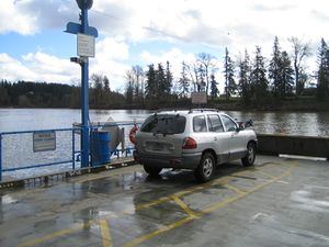
A car onboard the Canby Ferry
The Canby Ferry (aka the M.J. Lee) is a ferry in the U.S. state of Oregon that connects Canby, and Wilsonville/Stafford in Clackamas County across the Willamette River. It has been in service since 1914. It has been replaced and updated several times, most recently in 2001. It is one of three remaining ferries on the Willamette River.
The ferry has room for six cars (or 75 tons) and a toll is charged for motor vehicles, whilst pedestrians and bicyclists travel for free. A regular passenger car costs (2009 pricing) $2.00, while $12 is charged if a vehicle takes up the entire ferry. The ferry, the M.J. Lee II, is a cable ferry powered by electricity provided by overhead lines and is guided across the river by underwater cables, so the vessel is relatively unaffected by the river's currents.
The ferry is required by the Navigation Rules to display a day shape and, at night, certain lights that communicate to other vessels its (right-of-way) rights on navigable waters.[1] Because the ferry is guided by an underwater cable, and is fed electricity from an overhead cable, its ability to maneuver is restricted. Such vessels must display the day shape for restricted maneuverability which is a ball, diamond, and ball displayed vertically in the rigging. As the Canby Ferry is permanently with restricted maneuverability, the shipbuilders mounted a metal ball-diamond-ball on a mast. Before sunrise and after sunset, and during periods of restricted visibility, the ferry must display the red over white over red array of a vessel restricted in her ability to maneuver.
See also
References
- ↑ US Dept of Transportation, United States Coast Guard "Navigation Rules, International-Inland", COMDTINST M16672.2D, Paradise Cay Publications, Arcata, California ISBN 0-939837-49-8
External links
Coordinates: 45°18′00″N 122°41′35″W / 45.30012°N 122.69315°W / 45.30012; -122.69315


.svg)