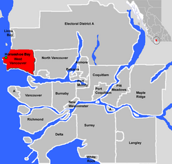
Horseshoe Bay, West Vancouver
Horseshoe Bay is a West Vancouver community of about 1,000 permanent residents. Situated right on the western tip of West Vancouver, at the entrance to Howe Sound, the village marks the western end of Highway 1 on the British Columbia mainland.
It is also the southern end of the Sea-to-Sky Highway, with Lions Bay just 15 minutes north. A major BC Ferries terminal is located here, providing vehicle ferry links to Vancouver Island, the Sunshine Coast, and Bowen Island, a small island in the southern part of Howe Sound. There are currently 3 berths at Horseshoe Bay, making it the third largest BC Ferries terminal, after Tsawwassen and Swartz Bay. In 2005 the Queen of Oak Bay ferry lost control and smashed into a number of private boats at the marina in Horseshoe Bay; no fatalities were reported.
Because of the presence of the ferry terminal, Horseshoe Bay is a control city on the Upper Levels Highway westbound.
Gallery
General photographs
- Horseshoe Bay, BC.jpg
Boats at Horseshoe Bay.
- Horshbay-mtns.jpg
Boats at Horseshoe Bay, with Howe Sound in the background.
- Horshbay-ferry-boats.jpg
Boats at the marina, with the Queen of Oak Bay docked on the right.
Ferry terminal
- Horshbay-ferry-lineup.jpg
Cars lining up at the terminal.
- Horshbay-ferry-dep.jpg
A ferry departing the terminal.
- Horshbay-ferrytermin-entrance.jpg
Entrance to the terminal.
- Queenofcapilano-horshbay.jpg
The Queen of Capilano arrives at the terminal.
Ferry Routes
| Horseshoe Bay | Destination | |||
|---|---|---|---|---|
| BC Ferries Route 2 |
Departure Bay Nanaimo | |||
| BC Ferries Route 3 |
Langdale | |||
| BC Ferries Route 8 |
Snug Cove Bowen Island | |||
External links
| |||||
Coordinates: 49°23′N 123°16′W / 49.383°N 123.267°W
| 40x30px | This Greater Vancouver location article is a stub. You can help Ship Spotting World by expanding it. |


