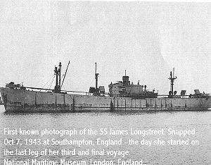
SS James Longstreet
 The SS James Longstreet before her last and final voyage | |
| Career | 100x35px |
|---|---|
| Name: | SS James Longstreet |
| Builder: | Todd Houston Shipbuilding Corporation, Houston, Texas |
| Laid down: | 3 December 1941 |
| Launched: | 2 April 1942 |
| Out of service: | Damaged by grounding in 1943 and written off |
| Fate: |
Acquired by the Navy in 1944 Sunk and used as a target until 1971 |
| General characteristics | |
| Class and type: |
Liberty ship type EC2-S-C1, standard |
| Tonnage: | 7,000 tons deadweight |
| Length: | 441 ft 6 in (135 m) |
| Beam: | 56 ft 10.75 in (17.3419 m) |
| Draft: | 27 ft 9.25 in (8.4646 m) |
| Propulsion: |
2 × oil-fired boilers 1 × triple-expansion steam engine, 2,500 horsepower (1,900 kW) 1 × screw propeller |
| Speed: | 11.5 knots (21.3 km/h) |
| Capacity: | 10,800 long tons deadweight (DWT) |
| Complement: | 41 |
| Armament: |
Stern-mounted 4"/50 caliber (102 mm) gun for use against surfaced submarines variety of anti-aircraft guns |
SS James Longstreet (Hull Number 112) was a Liberty ship built in the United States during World War II at a cost of $1,833,400. She was named after the Confederate general James Longstreet.
She was laid down on 3 December 1941, then launched on 2 April 1942. She ran aground in a gale in 1943 and was declared a total loss. Instead of being scrapped, she was acquired by the US Navy in June 1944 and used as a target ship for early air to surface guided missiles. Whilst under tow to and from the target areas, she once ran aground and on another occasion broke her anchor chain and drifted for ten days before being recovered. She was then sunk and used for further experiments using missiles, before then being used for live ammunition target practice by Naval jets from nearby South Weymouth Naval Air Station and the Air Force from nearby Otis Air Force Base until 1971. The ship is also referred to as the "target ship".
The remains of the James Longstreet lie approximately three and a half miles off Eastham, Massachusetts in 20 to 25 feet (6.1 to 7.6 m) of water. The site is off limits to divers due to unexploded ordinance.
External links
Coordinates: 41°49′53.27″N 70°02′39.28″W / 41.8314639°N 70.0442444°W
| This article about a specific Liberty ship is a stub. You can help Ship Spotting World by expanding it. |
