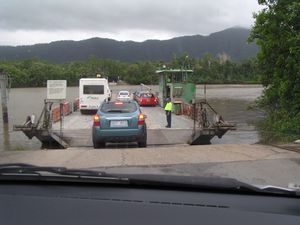
Daintree River Ferry
The Daintree River Ferry is a cable ferry across the Daintree River in Queensland, Australia. The ferry is situated some 50 kilometres (31 mi) north of Port Douglas, and gives access to the northern section of the Daintree National Park and to Cape Tribulation. The ferry provides the only sealed road access to this area.[1]
The ferry carries a maximum of 16 vehicles, and takes about 5 minutes to cross the river. It operates from 6am until midnight, seven days a week. The ferry is operated by a commercial contractor on behalf of the Cairns Regional Council, as successor to the Douglas Shire Council. A toll is charged for the crossing.[1][2]
At busy times, for example during school holidays, large delays can occur waiting to cross the ferry. The construction of a bridge or a second ferry has been discussed, but these have been rejected because they would increase the number of tourists and threaten the ecosystem of the Daintree Rainforest.[3]
References
- ↑ 1.0 1.1 "The Daintree River". Daintree Rainforest. http://www.daintreerainforest.com/river.html. Retrieved 2009-01-20.
- ↑ "The Daintree River Ferry Report". Queensland Ombudsman. http://www.ombudsman.qld.gov.au/Portals/0/docs/Publications/Inv_reports/Daintree_River_Ferry_Report_web.pdf. Retrieved 2009-01-20.
- ↑ "Current Events in the Daintree Rainforest". Daintree Rainforest. http://www.daintreerainforest.com/events.html. Retrieved 2009-01-20.
Coordinates: 16°15′35″S 145°23′54″E / 16.259854°S 145.398195°E
| 25px | This Far North Queensland geography article is a stub. You can help Ship Spotting World by expanding it. |
| This ferry article is a stub. You can help Ship Spotting World by expanding it. |

