NOAAS Okeanos Explorer (R 337)
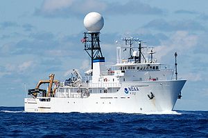
 Okeanos Explorer at sea with satellite dome over its bridge | |
| Career (United States) | |
|---|---|
| Name: | USNS Capable (T-AGOS-16) |
| Awarded: | 20 February 1987 |
| Builder: | Halter Marine |
| Laid down: | 17 October 1987 |
| Launched: | 28 October 1988 |
| In service: | 9 June 1989 |
| Out of service: | 14 September 2004 |
| Fate: | Transferred to NOAA |
| Career (United States) | 60px |
| Name: | Okeanos Explorer |
| Commissioned: | 13 August 2008 |
| In service: | 2010 (scheduled) |
| General characteristics | |
| Class and type: | Stalwart-class Ocean Surveillance Ship |
| Displacement: |
1565 tons (lightship) 2265 tons (full load) |
| Length: | 224 ft (68 m) |
| Beam: | 43 ft (13 m) |
| Draft: | 17 ft (5.2 m) |
| Propulsion: | 4 × Caterpilar D398 diesels, 3,200 hp; GE motors, 2x 800 hp; 2x 250 hp stern thrusters; 1x 500 hp bow thruster |
| Speed: | 10 knots |
| Range: | 9,600 nautical miles (18,000 km) |
| Endurance: | 40 days |
| Complement: | 6 commissioned officers, 3 licensed engineers, 18 crew, 19 scientists |
NOAAS Okeanos Explorer (R 337) is a converted United States Navy ship (formerly USNS Capable (T-AGOS-16)), now an exploratory vessel for the National Oceanic and Atmospheric Administration (NOAA), and will officially launch in 2010. Meanwhile, it is engaging in trial voyages before its maiden voyage planned for the Pacific Ocean, near Indonesia.[1] NOAA has entered into a five-year partnership with the San Francisco Exploratorium. The focus is on gathering scientific information about oceans for the public as well as for scientific uses. As much as 95% of the ocean remains unexplored, NOAA officials said.[2] The ship is equipped with cameras and will provide real-time viewing of the ocean floor for scientists and for the public.[1]
This is a pioneering use of what NOAA calls "telepresence technology".[3] The Okeanos Explorer is the only vessel owned by the U.S. government that is dedicated to exploring the seabed and ocean crust.[4] Its mission has been compared to the lunar landing.[5]
Contents
Description
The 224-foot-long (68 m) converted vessel is covered with cameras capable of high definition images, and sophisticated devices such as 3-D sonar mapping systems. It looks like an average ship, except for a 12-foot-wide (3.7 m) white ball, its satellite dome, mounted high above its bridge.[2] This will provide the ability to provide live satellite broadcasts. It also will have a ROV (remotely operated vehicle) with its own mini-ROV that will be able to descend nearly 19,000 feet (5,800 m) to the ocean floor.[6] The ROV, named "The Discoverer," will be tethered to the mother vessel and carry a small camera, to send back high-definition images.[1]
Voyages
The maiden voyage is planned for the Pacific Ocean, near Indonesia. Further trips are planned for the Black Sea, off the coast of Turkey, to investigate a graveyard where there are 2,000-year-old shipwrecks.[1][7]
Currently, it has already revealed that there are previously unknown features off the California coast. In the sea off Bodega Bay, an area containing 30 volcanic craters was discovered. Scientists on board saw deep fractures of the plates in the ocean crust off the coast of Eureka. They also identified a massive, previously unknown plume of gas thought to be methane.[1]
Education
NOAA is seeking to provide data for, and interact with, students, teachers, and anyone else who is interested.[2] For this purpose it is collaborating with San Francisco's Exploratorium to develop an online eductational programs with live broadcast for all ages and for the general public. They will "join the scientific expertise and observational resources of the NOAA with the creativity and educational expertise of the Exploratorium", a press release said.[8] The Okeanos Explorer is designed as an educational tool that can be followed on Twitter.[9][10]
Notes
- ↑ 1.0 1.1 1.2 1.3 1.4 "New high-tech ship will take ocean exploration to new, amazing depths". www.mercurynews.com. http://www.webcitation.org/5iuBiUDvf. Retrieved 2009-08-09.
- ↑ 2.0 2.1 2.2 Kerr, Dara. "Okeanos Explorer to delve the depths of the seas". news.cnet.com. http://www.webcitation.org/5iuBbg1uL. Retrieved 2009-08-09.
- ↑ Martinez, Catalina Martinez. "NOAA Ocean Explorer: Okeanos Explorer: A New Paradigm for Exploration: Telepresence". oceanexplorer.noaa.gov. http://oceanexplorer.noaa.gov/explorations/07blacksea/background/telepresence/telepresence.html. Retrieved 2009-08-09.
- ↑ "Telepresence Technology — Office of Ocean Exploration and Research". explore.noaa.gov. http://explore.noaa.gov/technology/telepresence. Retrieved 2009-08-09.
- ↑ Lubchenco, Jane. "A moonward gaze from a tidal shore - From Our Inbox - MiamiHerald.com". miamiherald.com. http://www.webcitation.org/5iuMqoUQx. Retrieved 2009-08-09.
- ↑ Perlman, David. "NOAA, Exploratorium chart a course for science". sfgate.com. http://www.webcitation.org/5iuBWDnLe. Retrieved 2009-08-09.
- ↑ "Institute for Archaeological Oceanography - Aegean & Black Sea 2007". iao.gso.uri.edu. http://iao.gso.uri.edu/iao/index.php?option=com_content&task=blogsection&id=4&Itemid=35. Retrieved 2009-08-10.
- ↑ "NOAA gets creative with Exploratorium". www.sfexaminer.com. http://www.webcitation.org/5iuCPJet1. Retrieved 2009-08-09.
- ↑ "NOAA, Ocean Explorer". oceanexplorer.noaa.gov. http://oceanexplorer.noaa.gov/. Retrieved 2009-08-10.
- ↑ "NOAA, Ocean Explorer (oceanexplorer) on Twitter". twitter.com. http://twitter.com/oceanexplorer. Retrieved 2009-08-10.
References
- "NOAA Ocean Explorer: Okeanos Explorer: A New Paradigm for Exploration". oceanexplorer.noaa.gov. http://oceanexplorer.noaa.gov/explorations/07blacksea/welcome.html. Retrieved 2009-08-09.
- "NOAA Ship Okeanos Explorer". www.moc.noaa.gov. http://www.moc.noaa.gov/oe/index.htm. Retrieved 2009-08-09.
- "Okeanos Explorer Education Materials Collection". oceanexplorer.noaa.gov. http://oceanexplorer.noaa.gov/okeanos/edu/welcome.html. Retrieved 2009-08-18.
| ||||||||
